
During this weeks holiday I had hoped to do the classic Scottish coast to coast mountain bike route that runs from The Kyle of Lochalsh on the west coast of Scotland to Montrose on the east coast. A big problem with doing this route are the logistics of getting yourself and a bike up to the starting point, I had hoped to take the train up to the Kyle of Lochaslsh but I was told all spaces for bikes were full up on the days I wanted. So instead I started looking around for alternatives ride ideas and came across a great one in a book called “Scottish Mountain Biking – The Wild Trails” by Phil McKane (Vertebrate Publishing). The ride was a 4 day tour of the Cairngorms and had the added bonus of taking in large chunks of the C2C route I had originally wanted to do. Also being a circular route I could drive up to Scotland with the bike in the car and then ride a big loop back to the car. I already had the four Landranger OS 1:50,000 maps I needed (35,36,42,43) from previous mountaineering trips up here and I set about penciling in the route onto the maps. The more I looked at it the more i realised what a great route it was, it turns out that the Cairngorms are ideal for cross-country mountain bike touring, I would guess that well over 90% of the route is off-road using estate roads, stalkers paths and ancient drovers routes through the mountains. In a nutshell the plan looked like this :-
- Blair Athol – Starting point, leave car here, ride to Kingussie.
- Kingussie – “The Tipsy Laird” bunk house, ride to Tomintoul.
- Tomintoul – The Smugglers Hostel, ride to Braemar.
- Braemar – Stay at the Youth Hostel and ride back to car at Blair Athol.

Cairngorms map and my route
I drove up on the Sunday and spent the night at Pitlochry Youth Hostel about 7 miles away from the start in Blair Athol and made an early start on Monday morning. Quiet roads and tracks follow the main A9 road to Dalnacardoch Lodge, where you cross the busy A9 and the wilderness riding begins on good wide tracks, through the forest to begin with then onto open countryside. The weather was quite wet for the first couple of days and this made crossing the numerous fords on the route quite tricky at times, sometimes having to wade knee-deep carrying the bike on my shoulders to get to the other side. The hardest riding of that first day was along the banked shore of Loch an Duin which was very narrow and boggy at times, after this it was good double-width estate roads past Gaick Lodge and then surprisingly tarmac road for a good while down Glen Tromie. At Tromie Bridge I turned left and headed for Kingussie passing the impressive ruins of Ruthven Barracks on the way, which was well worth a look around. I stopped at the basic but cheap bunk house attached to the Tipsy Laird pub on the main high street.
It rained hard all during the night and for most of the next day as I retraced my way past Ruthven Barracks to Tromie Bridge and picked up the trail to Glen Feshie, crossing a couple of fords on the way. The river Feshie was looking flowing strongly after all the recent rain and i crossed it at the wooden bridge and headed north up the hamlet of Feshiebridge passing the airstrip of the glider station on the way, i turned right here into the forest hoping to navigate myself to Loch an Eilein, i dislike riding in managed forests as it hard to know where you are exactly when surrounded by trees, especially with an old map and tracks going in various directions, however this time i got lucky and picked up the very nice small trail to the lovely Inschriach Bothy. I had been to this bothy a few years previous on a day walk with a couple of friends and it was good to come across it again. After a sandwich in the bothy and adding another layer i set off again on the narrow rocky trail down to Loch an Eilein and then picked up the wide smooth trails that lead to Loch Morlich via the Cairngorm Club footbridge.

Drakes Bothy near Loch an Eilein
There are lots of way-marked trail around this area and seems a good place to come for day rides. At Lake Morlich i joined the main road that heads up to the big ski centre passing the youth hostel and then branched-off left on the side road that leads up to Glen More Lodge – the Scottish National Outdoor Centre, a place i knew well from having done a couple of courses there many years ago. Continuing along this track brings you past a magical little lochan and shortly afterwards you branch left heading north past Ryvoan Bothy and into the forest, i missed the turn off right here for the ford and ended up at Forest Lodge and i done a u-turn here heading south then east to Loch a Chnuic, some careful navigation is needed here to pick up the small trail to the narrow cleft of Eag Mhor then it’s onto the Braes of Abernethy to the hunting estate of Dorback Lodge. It had been a long wet day so far but my target for the day of Tomintoul didnt seems so far away now, however as i set off across the moors to Letteraitten i came across several 4×4 vehicles and then the sounds of gunshots nearby and beaters waving white flags, there was a shoot in progress and my intended route over the moors to Tomintoul was not possible. i had to retrace my route to Dorback Lodge and then down the access road to pickup the main A939 road into Tomintoul, a road that had several steep climbs on it but then again Tomintoul is the highest village in Scotland! i finally reached the Smugglers Hostel at about 6.00pm tired and dripping wet, it had been a long day but an enjoyable one.

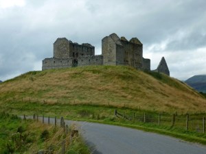
Day 3 dawned dull and misty but largely dry just the odd light shower, the target for today was Braemar directly south of Tomintoul. I was on the road by 8.30am and had a short tour up and down the long main street of the village before heading off down the road that turns into a track that follows the River Avon south. i followed this wide easy trail all the way down to Inchrory Lodge, where i left the river Avon and kept heading south into Glen Builg via a vague boggy section then an improved track to Loch Builg after passing some small lochans its south again to the flanks of Cullardoch where a very long climb awaits you. Just before the climb starts i came across a brand new shooting hut, a high-class one that wouldn’t look out of places on the slopes of verbier. Once the high point on Cullardoch is reached all difficulties for the day are over and its a very fast descent down to the forest where there are some very nice old Scots Pines to be seen. Invercauld House leads to the main road turning left over Invercauld Bridge and you pass the old bridge of Dee (Brig O`Dee) after a couple of miles Braemar Castle comes into view and then the village itself, after exploring the village a while and a very nice meal at a local cafe i checked into Braemar Youth Hostel.

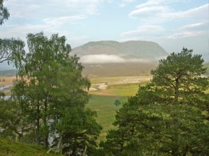
The narrow watershed area leading to Glen Tilt
Day 4 and the last day of this tour of the Cairngorms and the weather was the best yet, sunshine and light winds made the 6 mile ride along the tarmac to the Linn of Dee a pleasure, i stopped to take some photos of this impressive gorge before leaving the tarmac and heading west on a good track along the banks of the River Dee as far as the “White Bridge”. Here i left the Dee and headed south crossing the Geldie Burn and up to the ruin of Bynack Lodge, the grassy rocky track climbed steadily and was fairly obvious to follow as it made its way to the watershed and the start of Glen Tilt, here the valley narrowed sharply with the river and trail squeezed on both sides by steep grassy slopes. The very narrow trail became quite a technical challenge to ride with rocks peppering the trail and a large drop on the left hand side i got off and pushed a lot of this section. eventually after 2km or so the terrain opened out again and the going became a lot easier, shortly afterwards the Bedford Bridge came into view which provides a great viewing point for the spectacular Falls of Tarf waterfalls. All difficulties were now over as you follow the River down Glen Tilt, which was looking at its best in the bright sunshine, on a good track for mile after mile downhill, eventually joining the road at The Old Bridge of Tilt, not far from Blair Athol and my waiting car.
-

- Turn off just after Calvine
-
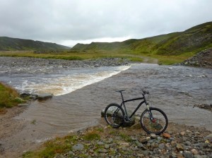
- Looking back on a tricky Ford crossing on the way to Sronphadruig Lodge
-

- Narrow boggy single track along Loch an Duin
-

- Approaching Gaick Lodge and Loch an t-Seilich
-

- Glen Tromie scene
-
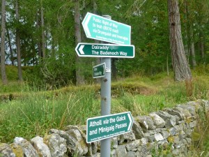
- Waymarkers near to Tromie Bridge
-
- The view from Tromie Bridge near Kingussie
-
- Ruthven Barracks near to Kingussie
-

- Ruthven Barracks info
-

- The bridge over the river Feshie
-
- Drakes Bothy near Loch an Eilein
-

- The Cairngorm Club Footbridge in Rothiemurchus Forest
-
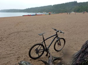
- Lake Morlich beach near to the watersports centre
-
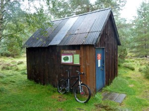
- Ryvoan Bothy
-
- The steep sided cleft of Eag Mhor
-
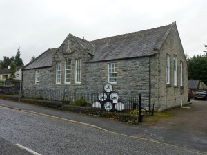
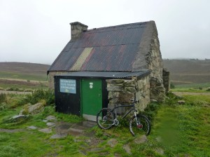
- The Smugglers Hostel in Tomintoul, which is the highest village in Scotland
-

- Ruin on the river Avon
-

- Trail just after Inchrory Lodge on the way to Braemar
-

- Trail leading to Invercauld House on the way to Braemar
-
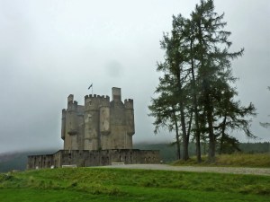
- Braemar Castle
-

- The Braemar Gathering site
-
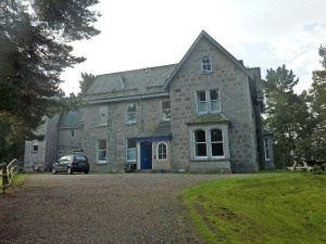
- Braemar Youth Hostel
-
- Early morning sunshine on way to The Linn of Dee
-
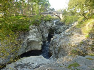
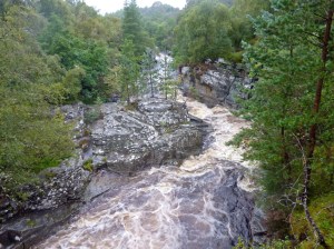
- The Linn of Dee gorge
-
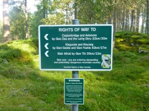
- Signs at The Linn of Dee
-
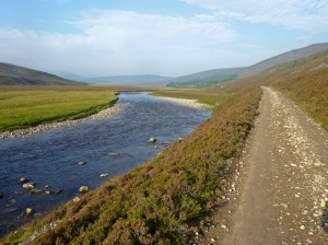
- River Dee track
-

- The “White Bridge” over the River Dee
-
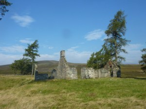
- Bynack Lodge ruin
-

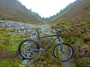
- The narrow watershed area leading to Glen Tilt
-
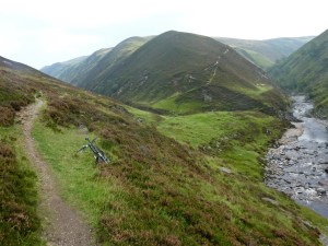
- The narrow watershed area leading to Glen Tilt
-
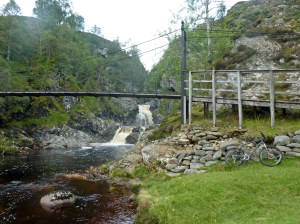
- The Bedford Bridge and the Falls of Tarf
-
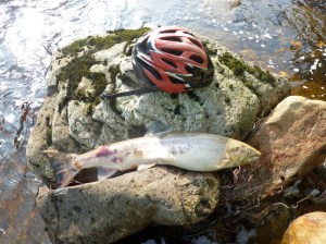
- Glen Tilt salmon?!
-
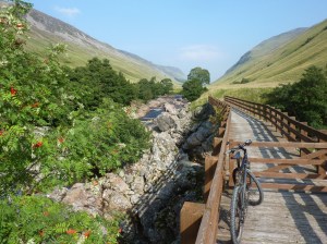
- Glen Tilt
